Digital Wisdom’s collection of Mountain High Maps for PowerPoint® Presentations is available for immediate download. Each set of maps is delivered as a Microsoft PowerPoint® PPT format file and can be easily and speedily edited within PowerPoint® application to create a map with a wide number of impressive variations to meet your presentation needs.
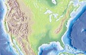 |
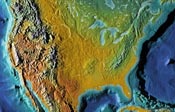
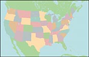
Each Mountain High Maps for PowerPoint® Presentations is delivered with a Mountain High Maps signature shaded relief map background. For each map in the collection, two distinct relief variations, and one political fill color version are offered. |
 |
|
 |
|
| Three alternate map textures - Elevation or Vegetation Style and Political Color Fill Style. |
|
To build your map, simply click on the slide with the map feature to be added, copy and paste to your master slide - result.... a beautifully customized high impact map! Detailed instructions are provided on slide 1 of each Mountain High Maps for PowerPoint® Presentations package. The choice of which layers you select and the sequence of pasting these layers on to the master slide can produce many different effects and styles. The Ocean / Sea fill can be selected, the fill color modified, and then pasted on top of the relief map texture to tone down or remove the sea-floor texture if needed. When building a map for a PowerPoint® Presentation, it's important to balance complex visual graphics and the basic purpose of the presentation. The PPT Maps package makes it simple to accomplish that balance through simple custom editing and only using the layers you really need. |
|
Digital Wisdom has been providing high quality Mountain High Maps graphics for over 12 years. We specialize in creating a highly unique relief texture that is used world wide in television, publishing, advertising and multimedia. Check our full collection of high resolution map graphics resources at www.relief-maps.com
PowerPoint is a registered trademark of Microsoft Inc.
Mountain High Maps is a registered trademark of Digital Wisdom Inc.
Digital Wisdom is a registered trademark of Digital Wisdom Inc.
MAP CATALOG • SUPPORT & FAQ • SAMPLE MAPS • CUSTOM MAPS • LICENSE • ABOUT PPT MAPS
©2014 Digital Wisdom Inc.